
+84 28 3930 9589
+84 28 3930 9269
 iscm@ueh.edu.vn
iscm@ueh.edu.vn
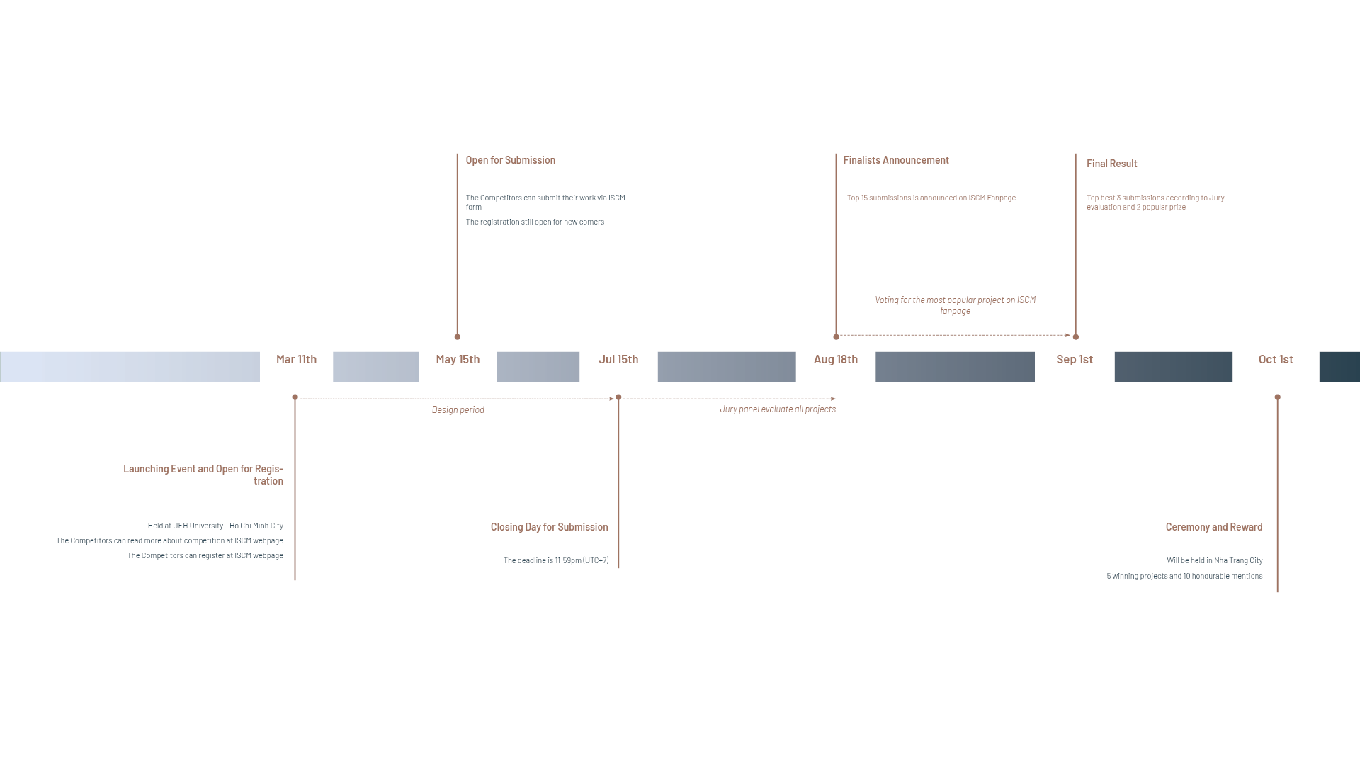
“From Ponagar Tower to the foot of San Mountain, Nha Trang - Khanh Hoa will soon have a heritage route along the Cai River.”
People’s Committee of Khanh Hoa Province
$ 3,000 to 1st Award 
$ 1,000 to 2nd Award 
$ 700 to 3rd Award 
$ 500 to Most Popular Award 
$ 500 to Sponsor Favourite Award
10 Honourable Mentions 
15 Finalists
Feature in A special session of Smart Urbanisms & Beyond Book series 
published by UEH Press
Experiment and Exploring Tour 
Exhibition and sharing with partners 
Opportunity to be supported with flight tickets and accomodation in Nha Trang City 
Opportunity to receive special awards from sponsors


Director, Institute of Smart City & Management
College of Technology and Design
Vietnam

Department of Engineering and Architecture
University of Trieste
Italy

Director of Master programs
KU Leuven University
Belgium

Head of Department of Landscape Architecture (DLA)
Faculty of Architecture & Planning
Vietnam

Department of Spatial Environment System Engineering
Handong Global University
Korea

Director of the Urban Design and Development International (UDDI) program
Thammasat University
Thailand

Coordinator of Master Programs
KU Leuven University
Belgium

Coordinator of the Laboratorio di Simulazione Urbana Fausto Curti
Politecnico di Milano
Italy

Senior Lecturer, Institute of Smart City & Management
Former Vice-Dean, Urban Planning Faculty, University of Architecture Ho Chi Minh City
Vietnam

Head of Department of Architecture
Faculty of Civil Engineering
Vietnam

Programme Director & Professorial Research Fellow
Singapore University of Technology and Design (SUTD)
Singapore

Assistant Professor at the Faculty of Arts and Humanities
University of Saint Joseph (USJ)
Macao

Lecturer, School of Communication & Design
RMIT Vietnam, Ho Chi Minh City
Vietnam

Interim Vice President for Advancement and Strategic Relations
The Boston Architectural College
United States

Associate Professor in Urban Planning and Assistant Dean, Diversity and Inclusion
University of Melbourne
Australia

Head General Planning Management Department
Department of Planning and Architecture
Vietnam

Dean, Faculty of Architecture
Khon Kaen University
Thailand

Lecturer, Faculty of Architecture
Khon Kaen University
Thailand

Academic Coordinator of Architecture bachelor's program, Senior Lecturer of Sustainable Urban Development master's program
Vietnamese-German University
Vietnam

Faculty of Civil Engineering
Ho Chi Minh City University of Technology and Education
Vietnam

Creative Director/ Landscape Architect
OMGEVING
Belgium

Department of Urban Planning and Design
Xi’an Jiaotong-Liverpool University
China

Associate Professor
Department of Smart Cities, University of Seoul
Korea

Lecturer, Faculty of Civil Engineering
Ton Duc Thang University
Vietnam

Department of Urban Planning and Design
Xi’an Jiaotong-Liverpool University
China

Faculty of Arts and Humanities
Macao

Head of Department of Architecture and Design
Faculty of Arts and Humanities
Macao

Department of Urban and Regional Planning <br /> Faculty of Architecture
Thailand

Director of the International Program in Design and Architecture
Faculty of Architecture
Thailand

Programme Director of Architecture
School of Architecture and Planning
New Zealand
56000+
audience
With urbanization on the rise, cities face growing challenges -from cultural loss to the need for human-centric design. Over the past 5 months of the 4th International Design Competition, thousands of people have voiced their passion and ideas, showing true commitment to shaping better cities for tomorrow.
500+
YOUNG TALENTS
By participating in the journey to (re)engage city landscapes for cultural and economic vibrancy, the next generation has taken its first steps toward shaping cities where innovation and tradition live in harmony — an essential path to a sustainable future.
30+
countries
With the mission “From Ponagar Tower to the foot of San Mountain – a heritage route along the Cai River”, the next generation unites across continents, bringing global visions to local challenges. Together, they aim to shape smarter solutions and create a better life for the people of Nha Trang, Khanh Hoa, Viet Nam.
AMONG 150+ CREATIVE IDEAS,
15 ideas have profoundly has left an indelible mark
voting period for Audience Choice Award 
21/08/2025 - 01/09/2025

the sacred pulse of the city
description
As a participant in the 2025 ISCM competition, our proposal, “The Sacred Pulse of the City”, reimagines the Cái River waterfront as a dynamic cultural corridor centered on Xóm Bóng. Located along the Cái River, the project aims to connect scattered green spaces and cultural landmarks, forming a vibrant heritage park landscape and a new transit core to attract tourists.
The first objective is to develop a continuous cultural trail along the river, integrating historical sites with walking paths, wayfinding signage, rest areas, and outdoor exhibition spaces to promote ecological connectivity and visitor engagement. The second objective transforms Xóm Bóng into a cultural-tourism focal point, hosting traditional performances, craft workshops, night markets, and folk festivals.
The strategic plan begins with transforming scattered green spaces into lush, connected areas. In the medium term, a heritage route on Xóm Bóng Island will be developed to link cultural destinations and provide interactive experiences. Long-term goals emphasize enhancing walkability and climate comfort through green infrastructure and riverfront activation, ultimately shaping a resilient, inclusive, and identity-rich urban landscape.

nha trang elasticity
description
Facing an increasing in urbanization and environmental degradation, this proposal aims to reimagine Nha Trang as a resilient and sustainable city by integrating green infrastructure, ecosystem restoration, and community-based eco-tourism. Through a landscape-driven strategy, the design seeks to increase urban flexibility, restore ecological balance, and enhance the city’s livability while promoting sustainable economic growth.
The core vision is to implement a long-term transformation plan based on urban resilience and adaptive landscape design, with an emphasis on reconnecting fragmented ecosystems, restoring flood-prone areas, and increasing biodiversity. A key feature is the introduction of an Eco-Tourism Route that stimulates the local economy, redistributes income to communities, and reinforces Nha Trang’s identity as an ecological destination.
The proposal is structured into three phases over 15 years, with clear, actionable goals.
Phase 1 focuses on flood mitigation and green recovery. Flood-prone zones are reclaimed as wetlands, while pocket parks are developed in underused urban spaces to increase community green areas. The use of blue-green infrastructure and bioengineering techniques—such as permeable pavements and water retention zones—helps manage stormwater naturally and cost-effectively.
Phase 2 emphasizes ecological connectivity and coastal resilience. A 6.5-kilometer Eco-Pedestrian Bridge is introduced as a new urban landmark, linking various ecological zones and encouraging biodiversity corridors. This phase also includes beach restoration, construction of artificial dunes and green beachfronts, and enforcement of LID policies requiring green roofs and designated green areas in new developments.
Phase 3 proposes Floating Green Platforms along the river to mitigate erosion, reclaim riverside flood zones, and expand urban green space. This complements Phase 1 by reinforcing ecological buffers and providing multifunctional green infrastructure.
Overall, the phases work toward enhancing sustainability in three key dimensions—environmental, social, and economic—by restoring natural systems, creating inclusive public spaces, and supporting long-term urban resilience. This proposal not only addresses current urban challenges but also ensures that Nha Trang evolves into a greener, more adaptive city with an enduring connection to its natural heritage.

pulse of unity
description
This project aims to address urban flooding while improving the quality of life in Nha Trang. The city, historically intertwined with water, now faces two major challenges: severe flooding and the erosion of local culture. Instead of tackling these issues separately, the project integrates them to create a holistic solution grounded in both ecological resilience and cultural revitalization.
The process began with a site analysis identifying areas prone to flooding and those rich in cultural heritage. These overlapping areas were selected for design interventions based on two key criteria: the intervention must not displace or negatively affect residents, and the site must support both water management and cultural revival.
The design classifies the intervention areas into six types, each responding to specific flood conditions and cultural characteristics. This approach creates multifunctional spaces that act as flood mitigation infrastructure, public gathering areas, and cultural landmarks. The guiding principles are: restoring natural systems, preserving traditional practices, and encouraging community activity. These spaces are designed not only to solve flooding issues but also to engage people and support long-term city vitality.
For example,
Areas with old fish ponds or natural retention capacity are turned into aquatic nurseries, conserving fishing traditions while improving water quality.
Mountain runoff zones become detention landscapes incorporating local crafts such as mat weaving.
Lowland agricultural areas affected by tidal backflow are developed into participatory green spaces combining water retention with community farming.
Coconut-growing areas transform into eco-tourism destinations with water infiltration zones.
Large fishing ponds become water parks, offering recreation and environmental education.
Riverfront zones are turned into wetland learning spaces using native plants for water purification and awareness-building.
In addition to addressing flooding and cultural loss, the project emphasizes accessibility and circulation throughout the city. Improved access leads to improved quality of life.
New networks of green corridors and public walkways are introduced to connect communities, allow better mobility, and integrate flood management functions such as stormwater collection and temporary storage.
By linking ecological functions with cultural identity, this project transforms vulnerable urban spaces into vibrant, resilient environments. It reimagines Nha Trang not just as a city adapting to climate challenges, but as a community that embraces its heritage and empowers its people through thoughtful design. The integration of ecology, culture, and accessibility provides a model for inclusive urban development that values place, history, and collective wellbeing.

rain traveler nha trang
description
This proposal centers on enabling uninterrupted tourism in response to the unique weather conditions of Nha Trang, Vietnam. Situated along the picturesque Cai River and the nation’s stunning coastline, the site presents exceptional potential as a year-round tourist destination. However, frequent rainfall and intense sun exposure pose recurring challenges for both local residents and international visitors. These weather-related interruptions have often led to concern and discomfort, particularly among foreign tourists unfamiliar with the region’s climate. As tourism represents a major driver of Nha Trang’s economy, creating a design that addresses these conditions is both timely and necessary.
The project introduces the concept of "Rain-Traveler" as its guiding principle. This idea prioritizes environmental responsiveness and user comfort by incorporating weather protection into every aspect of the design. The proposal emphasizes the creation of a continuous canopy system that shields public spaces, walkways, and circulation zones from rain and excessive heat. This intervention ensures that movement through the site remains uninterrupted, allowing tourism activities, local commerce, and cultural experiences to proceed regardless of weather fluctuations. The upper-level shading elements are designed with locally appropriate materials and passive ventilation strategies to improve user comfort while maintaining visual connectivity with the natural landscape.
Beyond protection from the elements, the proposal also reimagines the urban and social fabric of the area. New spaces are introduced to support both recreational and commercial functions. Covered promenades, open-air markets, and flexible event spaces are integrated into the layout to support a variety of tourism-related activities. These spaces are designed to be inclusive and adaptable, encouraging interaction between locals and visitors, creating opportunities for cultural exchange. As the number of tourists continues to rise, the plan anticipates the need for expanded infrastructure and diversifies the available forms of tourism. This includes eco-tourism experiences, water-based activities along the river, and curated cultural routes through the city’s historic and natural landmarks.
Sustainability and resilience are also central to the proposal. By addressing the climate directly through design, the project minimizes dependency on mechanical systems and reduces long-term maintenance costs. Rainwater harvesting, permeable surfaces, and green buffers are incorporated to manage stormwater and reduce urban heat island effects. These strategies contribute to the ecological health of the area while enhancing its aesthetic and functional qualities.
Ultimately, this proposal seeks to transform Nha Trang into a model of climate-responsive tourism infrastructure. It aims to strengthen the local economy by extending tourist engagement throughout the year and improving the quality of urban life for residents. By fostering a seamless connection between people, place, and environment, the design ensures that tourism remains not only uninterrupted but also sustainable, inclusive, and enriching for all who experience it.

river rhyme
description
River Rhyme is a visionary urban development project that reimagines Nha Trang as a resilient and compact city. At its core, River Rhyme advances an integrative strategy that links blue-green infrastructure, economic revitalization, and cultural continuity. Rather than resisting the forces of nature, this project tends to embrace them through the design of flood-adaptive public spaces, permeable surfaces, and landscape buffers that protect while inviting community life to the water’s edge.
In the way of life, Nha Trang’s rich cultural identity rooted in fishing communities, market rhythms and coastal rituals is not erased by modernization but reborn. By developing heritage trails, floating pavilions and co-designed districts reconnect the past with the present, re-engaging locals and tourists in a shared cultural experience that evolves with the city.
To enhance city economic vitality, this project shifts the focus from seasonal tourism toward self-sustaining urban vitality, guided by the principles of a compact city model through Transit-Oriented Development (TOD). This approach concentrates growth into walkable, mixed-use districts around mobility hubs, especially north of the Cai River, where access and opportunity have historically been limited. These TOD nodes act as new urban cores, enriched with jobs, housing, markets, and creative landmarks such as artisan villages and cultural plazas. The result is a more equitable and connected city, where prosperity spreads across the river, and every citizen can access work, services, and a higher quality of life without expanding the city’s footprint.
 Ultimately, River Rhyme is not just an urban plan. It is a living framework that flows with the city’s pulse and prepares it for an uncertain future. Resilient to storms, connected by design, and compact with care, Nha Trang is invited to grow not by resisting change but by learning to move with it. 
 “When the river speaks, the city listens.
 And when the tide turns, Nha Trang is ready to dance.” 

rebirth from the source
description
The proposal “Rebirth from the Source” envisions a bold transformation of the Cai River into the cultural and ecological heart of Nha Trang. Rather than treating the river as a boundary that divides urban life, the project repositions it as a vital lifeline that reconnects nature, people, and heritage. This vision emerges from a deep understanding of the river’s historic and symbolic role in shaping the city’s identity—both as a physical axis and as a source of collective memory.
At the heart of the masterplan are two primary goals: restoring nature and reactivating human life. On the one hand, the proposal introduces nature-based solutions—namely, mangrove corridors, eco parks, and green belts—to mitigate rising salinity, flooding, and climate vulnerability. These interventions are intended to create long-term resilience, enhance water quality, and restore biodiversity along the river's edge. On the other hand, the proposal also aims to revitalize public and cultural spaces to improve everyday life. This involves designing heritage trails, cultural squares, and community nodes that facilitate local services, celebrate identity, and encourage a vibrant 24-hour economy.
The masterplan is organized around three interlinked zones that address the site's urban and natural conditions. In the suburban zone behind the salinity dam, the strategy is ecological restoration through mangrove landscapes along railways and canals. The urban residential zone, under severe threat from flooding and salinity intrusion, is reconfigured with natural buffers—green corridors, eco parks, and aquaculture ponds—ensuring safety while providing tourism and recreational opportunities. And the service and tourism zone, where iconic landmarks like Ponagar Temple and Dam Market are located, is planned to integrate economic development with cultural identity. This involves shoreline protection, restored upstream mangroves, and lively public plazas celebrating heritage and commerce.
A narrative named "One River – Three Banks of Culture" threads through the plan, transforming the riverfront into a succession of meaningful experiences. It begins at The Bank of Origin, a spiritual space at the base of Ponagar Temple, continues through The Bank of Resonance, a living museum of Cham culture, and concludes at The Bank of Intermingling, where business and communal life converge at Dam Market. Collectively, these destinations reveal a city in harmony with its river.
Supported by a 12-year phased implementation plan, this proposal presents a definitive, actionable future. It builds a self-renewing urban ecosystem in which ecology, culture, and community are indistinguishably woven—giving Nha Trang not only a revitalized river, but a redefined identity.

threads city - stiching urban fabrics of nha trang city towards resilient civic prosperity
description
ThreadsCity proposes a transformative urban design paradigm for Nha Trang, addressing critical socio-ecological challenges—urban-river disconnection, erosion of traditional crafts, overreliance on tourism, and underutilized riverfronts—through the lenses of Landscape Urbanism and Nature-based Solutions.
Anchored in the Cai River and coastal ecosystems, this intervention reconfigures the city’s fabric by interweaving green corridors, cultural nodes, and community-driven spaces to enhance ecological resilience, cultural vitality, and economic diversification, aligning with the competition theme "(Re)engage cities' landscape for cultural and economic vibrancy."
Nha Trang’s rich heritage, including Cham weaving and fishing traditions, faces pressure from rapid urbanization, necessitating a multi-scalar framework—regional networks, urban revitalization, and neighborhood cohesion—employing adaptive processes such as Stitching within Community and Stitching along Communities.
This proposal fosters sustainable tourism—eco, cultural, beach—while promoting resilient civic prosperity, supported by transect tours, blue and green networks, and a craft promotion center, ensuring a holistic urban renewal.

threshold - design within the pulse of rising water
description
Set in the vulnerable delta of the Cái River, this project responds to the growing threat of flooding, spatial imbalance, and ecological degradation. But rather than treating water as an obstacle to be contained, the proposal begins with a simple yet radical premise: what if the river is not what divides the city, but what builds it?
The design concept is based on the idea of “The River Makes the City & The City Sustains the River”, where water becomes the spine of spatial, cultural, and ecological systems. Instead of a fixed border, the river becomes a gradient of adaptive life, around which new forms of dwelling, gathering, and economic activity are structured.
At the core of the strategy is a multi-tiered system of adaptive habitation: Floating houses in deeply flood-prone areas enable in-place adaptation; Stilt houses offer dual-function spaces above fluctuating water levels; Highland resettlement clusters on artificial landforms offer relocation options for the most exposed populations. These typologies are informed by topographic and hydrological data, overlaid with existing density patterns to address the inverse relationship between elevation and vulnerability.
A Heritage Axis forms the cultural and spatial backbone of the proposal. It connects temples, communal nodes, and vernacular clusters—linking the city back to the river and framing a narrative of place-based continuity. Along this spine, the design introduces: Floodable public spaces like a water square that changes character; Flood-adaptive tourism in underused lowlands; Floating markets and craft villages.
In parallel, the plan restores fragmented green zones into a continuous ecological buffer, improving biodiversity, flood mitigation, and urban cooling. Fragmented green zones are consolidated into a continuous riverine buffer, increasing permeability, biodiversity, and climate responsiveness.
Rather than a blueprint for resistance, the project offers a framework of coexistence. By allowing the river to shape new spatial, cultural, and ecological logics—and designing the city in return to care for that river—it creates not just a climate-adaptive solution, but a renewed urban ethos: to dwell with change, not against it.

resonance
description
Resonance envisions a living landscape in which heritage, nature, and urban life converge through shared rhythms, not as fragmented layers, but as a continuous pulse that breathes with the people of Nha Trang. The design is anchored in the belief that sacred landmarks such as Po Nagar Tower, the Sạn Mountain range, and the Cái River are not static relics of the past, but vibrant presences that participate in everyday life. They are remembered through rituals, embedded in craft traditions, and deeply rooted in the consciousness of generations who have grown up alongside them.
Rather than treating these elements as isolated icons, the proposal views them as parts of a larger, living ecosystem where urban infrastructures, cultural practices, and ecological flows are intimately entangled. The design seeks to synchronize the spatial experience of Nha Trang with the emotional and symbolic resonance of its cultural heart. Through this approach, the project redefines Po Nagar not merely as a sacred site, but as a center of gravity, a source from which spatial and cultural currents ripple outward and return.
The proposal introduces a layered network of interventions, beginning with a system of pedestrian and cycling corridors that connect Po Nagar Tower to nearby traditional villages, urban arteries, and riverside edges. These corridors are not simply routes, but narrative pathways, shaped with materials that echo the past, planted with native species that cool and filter the air, and embedded with visual and tactile cues that guide movement and memory. Along these paths, key nodes are designed as places of cultural interaction: small public squares, craft pavilions, interpretive gardens, and open-air stages that allow everyday life to blend seamlessly with ritual, history, and celebration.
Ecological features are carefully integrated throughout the site with green corridors along the Sạn foothills, flood-resilient wetlands near the Cái River, and porous paving that allows water to move and breathe with the land. Every design gesture is intended to remain subtle yet meaningful, drawing from Cham iconography, local vernacular architecture, and the soft transitions of the natural terrain.
Ultimately, Resonance is a proposal about continuity: not only of space, but of identity. It invites visitors and residents alike to move through a landscape that remembers—one where the breath of the city, the spirit of its people, and the pulse of its heritage are aligned in a shared rhythm of becoming.

(re)coding urban genes: towards circular scapes & economy
description
Nha Trang is one of the most famous coastal tourist cities in Vietnam. With the accelerating rate of tourism service development and increasing reputation, the waterfront area of Nha Trang is facing risk of overload. Along the Cai River area, high-rise hotels ruin the natural landscape of mountain and river, and people traveling there are increasingly burdening both the natural and cultural system at the estuary. The blue and green infrastructure are fragmented and discontinuous. The existing land use map is filled with disordered settlement and low accessibility in the area of Ngoc Hoi and Lu Cam. These conditions are necessary to be mapped with ecological zoning and construction viability maps.
On the other hand, the low recognizability of traditional and agricultural villages and neighborhoods contrasts with the burgeoning town near the sea with its low accessibility and lack of economic generators. As the tradition of ceramic and sedge mattress is slowly fading with very few households left for the craft, it is important that they are sandwiched between coastal tourism development and agricultural production, and become a place of connection between the two prominent areas along the Cai River. Learned from the case studies of economy and areas from Sweden and the Netherlands, a system for product and waste management that enhances product distribution and waste processing is necessary for the production market and defines different traditional values mixed with the modern tourism industry.
Therefore, we propose strategies to revitalize the traditional craft area with the concept of circular economy that not only enhances craft product distribution but also turns to reusing and recycling the residual materials from areas along the Cai River, contributing to the environment that is harmonized with the gifted greenery and the economic benefit of both river and coastal tourism. Following the strategies of ecosystem services provided and the economic enhancement cycle, the area in Ngoc Hoi and Lu Cam villages will become a place that nurtures innovations and recultivates the traditional craft, turning ceramic and sedge into modern useful products that serve contemporary needs. Not only does the new innovative neighborhood provide jobs for the community, but it also applies sustainable practices of urban biodiversity and flood mitigation.
The area aims to promote bicycle and walking through the positioning of condensed mixed-use offices and residential blocks that are within walking and biking distance in the area. This area provides ecological corridors for the residents and connects with the urban circular agricultural area on Ngoc Thao River Island that also aims to promote circular food strategies and water treatment around the island. In the neighborhood under San Mountain, the infrastructure that acts as a circular reuse center collects, recycles, and redistributes the products and continues the economic loop.
The area of Lu Cam and Ngoc Hoi serves as the place that closes the loop and complies with the natural, social, and economic cycles of the whole area along the Cai River. The area contains landscapes that mimic DNA strands and ceramic products.

nha trang +
description
Vietnam is a country with remarkable geographical diversity, ranging from high mountains, plateaus, dense forests, and river deltas to an extensive coastline and intricate limestone formations. This diverse landscape directly influences the economy, culture, and way of life across different regions, resulting in a rich blend of traditions and living patterns unique to each locality.
Nha Trang is a clear example of such diversity. The city’s landscape comprises the sea, mountains, and flatlands, allowing for a wide range of lifestyles and architectural expressions within the same urban fabric. While some coastal areas have been rapidly developed, others suffer from poor land use planning—such as misuse of coastal zones, land subsidence, and disconnection between the people and the river.
One of the city’s key challenges lies in the lack of relationship between the community and the Cái River, a vital waterway that nourishes Nha Trang in terms of ecology, culture, and everyday life. However, this river has been neglected and disconnected from the urban structure. Urban expansion and population concentration in the city center have led to the abandonment of riverside zones, resulting in imbalanced use of urban resources.
This project proposes to revitalize the Cái Riverfront and transform it into a public space that reconnects people, city, and nature. The design introduces a continuous riverfront park integrating walking paths, jogging trails, cycling lanes, and water transport routes. These paths meander along the river and are designed to adapt to the unique character of each neighborhood, reflecting local identity and offering users a variety of experiences.
Rest areas along the route are tailored to the surrounding context in terms of materials, form, and activity, while also functioning as natural barriers to erosion. The design incorporates renewable energy technologies such as solar power, wave energy, and kinetic energy from walking and running, which are converted into electricity for local use.
This project is rooted in the belief that: "A coastal city should offer more than just the sea." It aims to make Nha Trang a city that supports sustainable living and tourism in all seasons, at all times, and for all people—through flexible, lively, and meaningful design that reclaims and reactivates forgotten urban spaces.

the living heritage flow
description
The Living Heritage Flow proposes a holistic design vision that reinterprets the Cái River corridor as a dynamic interface between culture, ecology, and urban life. By intertwining the flows of water, movement, and wind, the design introduces a resilient framework that enhances natural systems, promotes cultural continuity, and creates inclusive public spaces. A key aspect of the proposal is the introduction of sediment trapping structures along river bends and banks. These structures encourage the accumulation of sand and silt, forming small islands that evolve into biodiversity habitats and community spaces. At the same time, vegetated embankments help stabilize soil and prevent further erosion while softening the urban edge.
The project also integrates Water Sensitive Urban Design (WSUD) to address water management challenges. Infiltration zones, constructed wetlands, and decentralized wastewater treatment systems are distributed across the site to purify runoff, increase groundwater recharge, and reduce urban flooding. These systems are designed to be visible, allowing users to understand and interact with the water cycle, making sustainability part of everyday life.
In tandem, Nature-based Solutions (NbS) are applied to enhance environmental quality and social well-being. Pocket parks, naturalized play areas, green walkways, and shaded rest zones are embedded in residential and commercial areas. These spaces support biodiversity, improve microclimates, and encourage social interaction, particularly in vulnerable communities.
The proposal is structured in three adaptive phases:
 Phase 1: Protection – Establish erosion control zones, increase permeable surfaces, and raise community awareness.
 Phase 2: Restoration – Restore wetland functions, connect green spaces, and begin community-based development.
 Phase 3: Preservation and Activation – Maintain the revitalized landscape and introduce cultural heritage trails that guide locals and visitors through significant landmarks, stories, and public art.
A built-in monitoring system tracks performance indicators such as water quality, biodiversity presence, and public engagement. These data sets inform management decisions and allow the system to adapt over time.
Ultimately, The Living Heritage Flow is more than a spatial intervention—it is a strategy to reweave natural and human histories through landscape. It invites people to reconnect with place, participate in its care, and rediscover the river as both a living ecosystem and a vessel of cultural meaning.

(re)urban - revitalizing the riverfront city
description
1. Project Vision: A Living Urban River
 The “(Re)Urban – Revitalizing the Riverfront City” project proposes a transformative reimagining of the Cái River as more than just a geographic feature. It is a cultural spine, a community hub, and a natural infrastructure that must be restored, preserved, and enhanced. By re-integrating the river into the heart of urban life, the project aims to make it a vital part of Nha Trang’s daily rhythms—supporting both tourism development and the wellbeing of local residents.
2. Urban Challenges: Disconnection, Decline, and Displacement
 Decades of spontaneous, uncoordinated urbanization along the river have led to fragmented land use, environmental degradation, and social disconnection. Traditional craft villages, religious spaces, and communal areas have been eroded or isolated. The river, once a symbol of connection and continuity, now stands at the edge of urban life—visually present but functionally disconnected.
3. Design Principle: Patchwork Planning – Stitching the Old and the New
 A central concept of the proposal is the application of a “patchwork planning” approach—a strategic method that preserves valuable existing structures while “perforating” them with new interventions. Instead of demolishing or replacing entire areas, this approach “keeps the old” where heritage, memory, and community value remain strong, and “makes holes”—literally and metaphorically—to insert new programs, infrastructures, and connections.
 These “insertions” include pedestrian greenways, soft embankments, cultural spaces, and public amenities, which are carefully layered into the existing urban fabric. The result is a living system that grows organically—bridging past and present while leaving room for future adaptation.
4. Spatial Strategy: Integration of Nature, Culture, and Everyday Life
 • Ecological Restoration: Implementing soft, adaptive embankments and rainwater landscapes to stabilize soil, reduce flooding, and support biodiversity.
 • Cultural Regeneration: Reviving craft villages and sacred sites as anchors of memory within the evolving cityscape.
 • Community-Led Insertion: Introducing small-scale, flexible interventions—pocket parks, floating platforms, or community gardens—within leftover spaces, unused lots, or informal settlements.
 • Flexible Connectivity: Creating permeable paths and public corridors that link the river, mountains, and residential areas.
5. Conclusion: Weaving Together Memory and Innovation
 By embracing the patchwork method, this project respects the layered complexity of the Cái River area. It refuses the tabula rasa approach, choosing instead to heal the urban fabric, stitch together what remains, and carefully introduce the new. The river is transformed into a connective, living infrastructure—where nature, memory, and modernity coexist. It becomes a space not only of flow and function, but of belonging, identity, and urban resilience.
Thank you for your attention and valuable time.
 This project represents the collective effort of our team, developed through direct field observation, careful analysis, and a shared aspiration for the future of the Cái River in Nha Trang. We sincerely hope that our proposal will contribute to a vision where the river becomes greener, more vibrant, and more connected to everyday urban life.
 We are deeply grateful for the opportunity to share our proposal with the esteemed jury and appreciate your consideration, insights, and support.

synth trang
description
SYNTH TRANG proposes a transformative vision for Nha Trang as a unified and experiential destination—a place where nature, culture, mobility, and everyday life converge into a seamless whole. Rather than separating tourism functions into isolated zones, the project reimagines the city as a continuous landscape of experiences defined by connection, regeneration, and local identity.
At its core, the proposal reframes Nha Trang as "One Destination, All Experiences." It positions the city not just as a collection of attractions, but as an integrated system where visitors and residents share spaces, movement, and meaning.
The strategy is built on four key pillars:
 1. Destination Power – Establishing Nha Trang as a singular and memorable destination through culturally resonant landmarks, iconic public spaces, and storytelling that highlights both tradition and transformation.
 2. Experience System – Designing a journey that weaves together cultural and natural assets. The west side of the city focuses on heritage, community-based tourism, and urban vibrancy, while the east emphasizes nature-based experiences—beaches, islands, rivers, and mountains—linked through soft mobility and coherent spatial rhythms.
 3. Regenerative Urbanism – Breathing new life into underused and fragmented areas of the city. A key feature is the conversion of the old railway corridor into a dynamic mobility and public space spine, serving as a new multimodal transport hub and central node of connection.
 4. Ecological Framework – Restoring and enhancing the city’s ecological base through wetland protection, urban greening, green-blue corridors, and distributed pocket parks. These systems support climate resilience, biodiversity, and quality of life for both residents and visitors.
Key features include:
 • A central transport hub that unifies land, water, and tourism mobility networks across the city and nearby destinations.
 • A flexible spatial structure that organizes the city into experiential zones without rigid boundaries, allowing adaptability and evolution.
 • Scalable public spaces that respond to different urban conditions, fostering inclusion, identity, and environmental care.
Rather than focusing on a single object or signature building, SYNTH TRANG offers a new way of thinking about the city—as a composition of relationships, rhythms, and experiences. It invites Nha Trang to evolve as a shared platform for exploration, regeneration, and connection—by locals and for the world.

miracai - a journey through stories and streams
description
As Khanh Hoa aims to become Vietnam’s sixth centrally governed city, the Song Cai Heritage Axis emerges as a key link to Dien Khanh and a strategic foundation for this vision. It is set to become a hub of culture, tourism, and services—complementing the city’s commercial and administrative centers.
Vision 2025: Transform the Song Cai Heritage Axis into a “Living Heritage” that meets ASEAN standards.
GOAL 1: PRESERVE, PROMOTE, AND DIGITIZE HERITAGE
Slogan: “Sun and Moon shine as one, casting a light of perfect clarity.”
Meaning: This symbolizes the harmony between the sun and the moon, reflecting the union of tangible and intangible heritage values along the Song Cai River. Song Cai's heritage encompasses not only culture, nature, and people, but also the collective memory of past generations—a memory illuminated by the radiance of the sun and reflected by the light of the moon on the river. It is a call for a civilized, enlightened future, grounded in a rich and vibrant legacy.
Guiding Principle: Heritage is the backbone.
Key Solutions:
Develop cultural building clusters: a folk performance theatre, water puppet stage on the river, spiritual museum, a wishing bridge for flower lanterns, and Ngu Ong festival boat races.
Create a Craft Village Square for skill-sharing in traditional crafts, empowering local residents to take ownership of their heritage while stimulating the local economy.
Establish a unified design language for all architectural interventions along the heritage axis.
GOAL 2: RESTORE ECOSYSTEMS AND IMPROVE COMMUNITY WELLBEING
Slogan: “The flowing river grounds us – heritage breathes through its veins.”
Meaning: The Song Cai River, a primal element of nature, should guide the formation of both architectural and landscape forms. The river is not merely a backdrop but a lifeline, carrying the energy that sustains culture and community identity.
Guiding Principle: Ecology as a frame.
Key Solutions:
Responding to climate change scenarios by mapping flood-prone areas and adapting housing, landscapes, and infrastructure accordingly. Integrate green energy, self-sufficient systems, and permaculture-style riverside gardens to ensure sustainability.
Convert flood-prone lowlands into central parks with constructed wetlands for natural water filtration and irrigation. Introduce productive green spaces that double as urban agriculture zones, public parks, and recreation areas.
Establish riverside trade markets for local food systems, including grocery stalls, agricultural and seafood markets, and daily-use shops.
GOAL 3: CIRCULAR ECONOMY DEVELOPMENT
Slogan: “Circular by nature – from soil to value, back to soil.”
Meaning: Products are created from the earth, used for their value, and then returned to the soil through composting, recycling, and regenerative systems—completing a cycle of continuous sustainability.
Guiding Principle: Circular economy, night economy.
Key Solutions:
Develop a closed-loop economy: farming → food production → local products → waste → compost → water filtration → farming again.
The night-time economy is driven by riverside beer halls, night markets, restaurants, cafés, light performance centers, folk theaters, water puppet shows, and other cultural and recreational venues.
Implement smart technologies to support supply chains and essential services in isolated or vulnerable zones. Integrate fire detection and early warning systems; repurpose surface water reservoirs into automated irrigation and firefighting networks.


